
Autumn is my favorite time to hike. The temperature is cool, the air is crisp and the views of foliage in September and October are ever changing palettes of red, orange, yellow and sienna. It is a great time for everyone to get outdoors and be active if only for a walk. If the mountains don’t call to you, there are many country roads full of colorful vistas to explore on foot. So grab a friend, a partner or a grandchild and get outside!
In the past two weeks I did two very different hikes in my home state of Vermont. One, a moderate hike in the Northeast Kingdom, could be done by anyone who is reasonably fit. The other, a more strenuous hike, needs some experience with hiking and a certain amount of preparation. It is always wise to know where you are going, what it requires in effort, and how to dress and eat for the trail that you pick. If you need some tips on what to take on a day hike, look here.
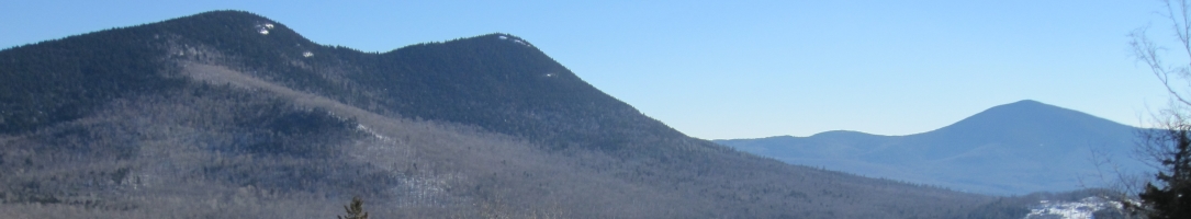
Wheeler Mountain
On the first week-end in October, the day dawned crisp and clear with temperatures predicted to be near sixty degrees; a perfect day for an autumn hike. The leaves were slightly past peak but those famous red maples, yellow birch and burnished oaks of Vermont were still impressively beautiful. My partner Roger and I jumped in the car to drive the 40 minutes to the trailhead at Wheeler Mountain in Barton, Vermont, one of my favorite hikes. Wheeler Mountain trailhead is located in the Northeast Kingdom and starts two miles up a dirt road that is 5 miles from the small town of Barton.
We had just finished breakfast and this is a short hike, so we took only hot tea with lemon and some homemade oatmeal cookies that are as dense as fitness bars. If you need to buy a lunch, stop in at the Step Back Café in Barton which will prepare take-out sandwiches for you. This is also a place that does not have a “bathrooms for customers only” sign on the door, so it’s a welcome last pit stop before the trailhead (but please try to buy something if you use it; we want them to keep it available to the world!).
The trailhead parking lot holds only five cars and the hike crosses private land so be especially good about carry in and carry out. Wheeler is a small mountain, elevation 2371 feet, but for much of the hike you are on smooth granite slabs with spectacular views of the Northeast Kingdom. It feels like you are much higher and more remote since there are few houses in view. There are two routes up—Red and White—which converge just below the top. The White trail is my choice: it is less steep than the Red but still has the feel of a rock climb. My friend Carolyn, who has some fear of heights, actually crawled on all fours some of the way on a previous hike here! Roger and I made it to the summit in less than an hour(elevation gain 700 feet) and continued a bit further to Eagle Cliff which gives a spectacular view of Lake Willoughby, Mt Pisgah and Mt Horr.
There was a family of three, parents and a teen, having lunch when we arrived. After our tea and cookies (Roger is British!) we descended to one of the many huge granite slabs to sit in the sun. The rock we were sitting on was so warm that we were tempted to take a nap. Below us we could hear another family, this one with young children, as they talked and laughed on their way up the trail. As the terrain steepened, the parents held the kids’ hands. I loved seeing the excitement on all their faces. Roger and I returned to the car relaxed and content that we could leisurely enjoy such a beautiful, open, yet relatively short hike.
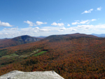
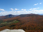
Stowe Pinnacle-Hogback-Skyline-Mt. Hunger
The next week-end was a different story. This hike is still in Vermont, still reasonably accessible, but definitely not a “family” hike. Carolyn, Cindy and I (all 50+ in age) had been pining to do the Skyline trail in Central Vermont for quite awhile and our schedules dictated that this would be the weekend. The hike requires a car drop—one in Waterbury, Vermont at the Mt. Hunger trailhead, the other at the Stowe Pinnacle trailhead in, of course, Stowe. Since this was a long hike we would do a potluck lunch with each of us bringing plenty of food to share. We also made sure we had the needed equipment and clothing for a long hike: hat, gloves, layers, wind protection, a first aid kit and of course, a map.
Our day started with breakfast at the Green Goddess, one of our favorite cafés in Stowe. I had half a Goddess sandwich—cheddar , spinach, egg and mushrooms on foccacia, plus a raspberry peach muffin, Carolyn had Huevos Rancheros( eggs served upon lightly fried corn tortillas topped with a tomato-chile sauce with a side of quacamale and refried beans) and a muffin; trim Cindy had oatmeal with raisins and maple syrup. Clearly, we needed a serious hike after that breakfast!
The temperature on my handy-dandy back pack thermometer said 40 degrees as we started on the hike at 8:45. I figured it would take us about 5 ½ hours to complete given a few stops along the way and the fact that the elevation gain was 2200 feet. At any rate we were prepared for a long and possibly strenuous hike.
Stowe Pinnacle is the first peak you climb on this 6.3 mile trip; since we had done the hike to the pinnacle together many times we knew what to expect. As we turned onto the Hogback Mountain trail our memories, like the trail, were a bit more remote. Cindy had done the hike about 3 years ago; it had been about 12 for me; for Carolyn, this was a first.
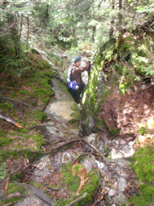
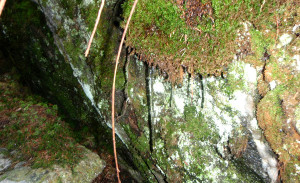
The trail wound through the forest, climbing through magical moss-covered rocks. We stopped often to admire the fairy-like places with red lichen on the rock and fungi on the trees. We continued our hike up Hogback—sometimes going vertical through the rocks, sometimes slipping on wet leaves, always laughing and musing on the beauty of the trail. I had remembered the trail as being more in the open but this hike was mostly through the woods with occasional long views to the East or West. The past week had been rainy and the mountain terrain was wet, wet, wet. Water dripped off rock, mud slurped underneath our feet and the bogs we slogged through slowed us down.

By the time we were almost to the top of Hogback we were cold and needing to replenish our energy. Cindy had brought just the thing—red pepper soup! Along with Carolyn’s brie and baguettes we were happy. The stop was short because of the temperature—the thermometer now registered 33 degrees and we couldn’t find a dry place to sit–we ate standing. We could see our breath as we ate and Cindy’s fingers were really cold; she did not pack the usual hand warmers, assuming it was too early in the year to need them. The rest of the food could come later; we needed to keep moving.
At the top of Hogback, I changed into a dry wool shirt and put on a hat and a pair of gloves. I’m a hot hiker who sweats no matter the temperature so I always take a change of clothes with me. Cindy and Carolyn commented on the steam rising out of the water on the trail and the icicles on the rocks and the goose bumps on my skin.
When the trail came to a T at the Skyline trail we figured we were probably at the height of the land. Skyline goes southwest to Hunger Mountain and northeast to Worcester Mountain (a relatively new addition to the network). What we hadn’t known was how much elevation we would lose before we would again start climbing to Hunger Mountain! The trail stayed wet and muddy and steep, both down and up. We saw 3 people coming our way on Skyline from Hunger—the only hikers we encountered. Carolyn slid on her butt twice, and me once—saved by our packs from getting hurt. Cindy was the only one who didn’t fall and the only one who seemed to be able to jump down the rocks. Of course she is also the youngest, the slimmest and the one who ate the healthy breakfast!
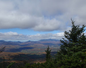
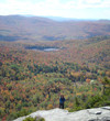
We were relieved to finally come to the level section of the hike with open views to Hunger. It actually felt like we had climbed that 2200 feet gain more than once with all the ups and downs! We could see other hikers in the distance at the top Hunger. Almost there! When we reached this last summit it was a sunny 38 degrees. It felt much warmer in the sheltered nook we found to finally have a full lunch: liver pate, bagels, a roasted potatoes, squash, and onion dish, marinated broccoli with sesame seeds, orange tea with lemon and homemade brownies. A great lunch at any time, but pure luxury after the long, hard hike! Of course we still had a steep two mile hike down to our car–but it was all downhill from here. As we got to the end of the trail, the people coming up wore only t-shirts. It must have been a warm afternoon in the valley.
The hike took us almost seven hours. We were tired, wet, dirty, and very pleased with ourselves. Cindy was looking forward to her hot tub, and Carolyn and I to a good soak in a hot bath at our respective homes. We would all have to do some serious stretching after this hike!
For more hikes in Vermont check out the Green Mountain Club website. Get out and enjoy the fall, snow will be here soon!