
Our friends Rich and Suzanne got married on a late summer Saturday that hinted of coming autumn, so my sweetheart Marilyn and I spent a beautiful, cool afternoon and evening all dressed up with lots of nice people around. They are a wonderful couple, it was a lovely outdoor ceremony, and a great party after, and we throughly enjoyed the whole experience. But by Sunday morning, we were ready to get away and enjoy the rest of a long weekend being Active Outdoors. I don’t know about you, but I prefer hiking boots to dress shoes.
The wedding wasn’t far from Springfield, Mass. Searching around for nearby opportunities, we chanced upon the AMC’s Noble View Outdoor Center in Russell, Mass. Though we regularly visit AMC lodges and huts in New Hampshire and Maine, we’d never stayed at Noble View. Instant getaway!
Berkshires Hiking: Grand Arches
I’ve always contended that there are outdoor opportunities everywhere. When we booked our night at Noble View, I asked the volunteer caretaker, Gary Forish, about dayhikes nearby. While there are a number of short hikes which start and end right at Noble View, Gary (like all AMC folks an enthusiastic outdoors person), recommended the Keystone Arch Bridges Trail about 20 minutes away in Chester. Great choice, Thanks Gary!
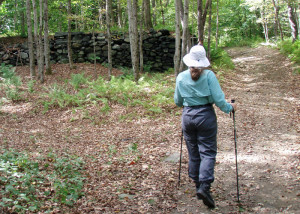
The trail starts off Middlefield Road about two and a half miles out of “downtown” Chester. At the trailhead you find the first of several large signboards which give you the history of the bridges and the railroad that created them. The trail, which essentially parallels the Westfield River, starts on a rough dirt road–clearly used by off road vehicles–but soon departs for a more sylvan route along a sidehill. Almost instantly you begin seeing signs of the stonework that defines much of human activity in this area. A mile or so out, a modern pedestrian bridge (made of wood and metal, not stone but still functional) gets you across a steepsided gully and a little trickle marked on the map merely as “Unnamed Stream.” Watch your step where the trail tuns and parallels the gully–a slip could prove, well, interesting . . .
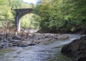
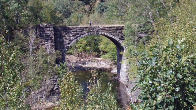
Eventually the path turns again and follows the sidehill until it meets again with the old road near a spectacular span of hand-cut stones dry-laid without an ounce of mortar. Please understand that I don’t use the word “spectacular” lightly . . . this is an absolutely gorgeous structure in a beautiful setting, a worthy destination for a walk (or mountain bike ride). Take a moment while you are here to imagine the work of many hands that produced this testament to human ingenuity and the engineer’s art.
These were the first such railroad bridges constructed in North America and several are still standing proudly when several more modern and presumably “better” bridges in New England had washed away only three weeks before in the floods brought by the remnants of Hurricanes Irene, Lee and Katia. Like the bedrock they rest on, these bridges are going to be here for a very long time.
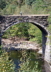
We’d had a leisurely day planned and this was a perfect hike, not too long and not too hard, but rewarding all the same. Compared to the White Mountains of New Hampshire, this is very, very easy walking. By the time we had reached the bridge and taken our photos, the sun was already arcing noticeably toward the horizon. Though we had headlamps in our packs, in case darkness overtook us, we decided to turn back rather than continue on to explore other bridges farther up the trail. We wanted a chance to see Noble View in full daylight on a bright afternoon. Besides, the unseen bridges will almost certainly lure us to return.
There were the slightest hints of color in a few leaves on this late-summer day. But I can only imagine how beautiful this hike will be in a couple of weeks when the leaves are turning. If you happen to go on this hike on a sunny day when the autumn colors are in full display, please take a photo of the bridge and send it to me (timjones@easternslopes.com). There’s a short trail from the east end of the bridge out to the railroad tracks which offers one of the best vantage-points for a photo. I’d love to see (and share with other EasternSlopes.com readers) what we missed by not being there at the right moment.
Berkshires Hiking: Noble Lodging
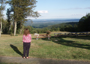
You don’t really notice it as you drive up General Knox Road, up South Quarter Road, then up the long gravel drive to Noble View, but “up” is the key concept in reaching Noble View. When you step between the newly renovated “Double Cabin” and “North Cottage,” the tremendous view to the east grabs your eyeballs and drags them over Westfield and Springfield. You’re slightly surprised that you can’t see the skyline of Boston. Or maybe even the Alps. The view seems to go on forever.
I can tell you for certain it’s even more spectacular at night with city lights twinkling below, and at sunrise on a cold, clear autumn morning when the sky is a brilliant orange. By the way, though the view is definitely noble, the property name came from the Noble family which bought it in 1825. The AMC purchased the property in 1931 and has added to it since. There are 17 miles of hiking and cross-country ski trails on the 360-acres.
A bunk at Noble View is $26/night for AMC members, $28 for non-members. A bedroom with two bunks is $40/$44, four bunks $76/84, you get the picture. There’s no plumbing in the cottages, though there’s a 6-burner range, refrigerator, a good complement of kitchenware and plenty of space to cook for a group.
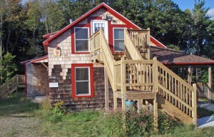
There’s indoor plumbing (showers, sinks, toilets, a restaurant-style sink for washing dishes) in a beautiful new bathhouse, but it’s a short walk to get there. The bathhouse has solar panels on the roof which supply most of the electricity used on the property, the toilets are flush-composting models, there’s plenty of hot water. It’s all very green technology and the three remodeled buildings are accessible for people with disabilities.
Noble View gets a lot of use on weekends by Scout groups and various service organizations, but some weekends are empty (what a place for a family gathering!) Midweek, it’s perfect for a quiet overnight getaway with all outdoors around you.
Sad Commentary
The Keystone Arch Bridges Trail intersects at several points with old roads that are, apparently, heavily used by off road vehicles. While I’ll readily admit that I’d prefer to see people getting exercise and fresh air by walking or riding a mountain bike in this beautiful setting, the four- wheelers hadn’t done much damage to the road other than a few deep tire ruts in muddy spots and, perhaps, contributing to erosion in a few others.
Absolutely appalling, however, was the amount of litter—mainly blue Bud Light cans—strewn along the jeep roads, especially where repeated large “campfires” had been built. Shame on the thoughtless renegades who regularly desecrate this beautiful spot. By the way, in case you are wondering, there weren’t any beer cans at all along the sections of trail accessible only to hikers and mountain bikers.
It doesn’t have to be this way. Snowmobilers, for example, have done a marvelous job of organizing clubs which, in turn, educate their members on responsible riding and contribute heavily to trail maintenance and upkeep. In my experience, the vast majority of snowmobilers are good citizens. It’s rare to see litter anywhere snowmobilers ride.
To me, it looks like it’s time for the responsible majority in the ATV and 4WD community in this area to step up, organize and educate its members. Maybe the brewing companies could do more to educate their consumers as well . . . Other that that, the only remedy I can see is increased law enforcement.
Another Sad Comment
Apparently, efforts to preserve and protect these amazing stone structures are being frustrated at every turn. See the comment below from David Pierce. . . .


I’m Dave Pierce, founder and director of Friends of the Keystone Arches, Inc. an advocacy group for the bridges you visited. We appreciate the recognition. We are the builders of the trail, a mostly volunteer effort, with lots of help from local school kids and teachers (Gateway Regional District), as well as a couple AmeriCorps sessions.
The real story here is the lack of recognition for these bridges and the incredible history behind them. Would you be surprised to learn that every major preservation organization (public and private) in MA, has declined their custodianship? This in spite of the fact that they are listed in the National Historic Inventory, The Historic American Engineering Record (Library of Congress), the 10 Most Endangered Historic Resources in MA list, the 1000 Great Places in MA list, as you suspected, the Best Foliage Spots in MA list, as well as the 2007 Editor’s Choice List of YANKEE magazine. We are presently preparing a nomination for Historic Landmark status, which the National Park Service assures us we have a good chance of winning.
Would you be surprised to learn that there is a 1.5 million dollar Interstate Transportation Enhancement Act grant from 1996 to repair the bridges, which we have yet to implement as we negotiate endless regulations surrounding the Wild & Scenic Westfield River and are held at bay by CSX Transportation, which controls the only possible vehicle access? (This is the largest roadless wilderness in the state.) Our funding was removed from the TIP list by MA DOT last year, so we are now battling to have it restored in tandem with the previously mentioned obstacles.
The two abandoned arches are the property of MA Fish and Wildlife by default, but monument preservation is not in their mission statement. In fact, this and another trail we are just starting along Walker Brook in Chester, are the only two formal trails on F&W property in the Western District and both exist only due to the extraordinary historic sites along them, as F&W prefers to leave properties in as natural a state as possible.
As yet we have been unable to get any of our local legislators to take the time to hike out to see them, though most profess and have offered, support. Sen. Michael Knapik presented a Senate resolution this past May which recognizes the bridges as part of the world’s first mountain railway, as well as the first major American infrastructure project to employ large numbers of immigrant laborers.
This is a very brief summary of why any publicity is greatly appreciated. That, along with the trail itself, is how we hope to win over a constituency for them; basically we are reaching out to one person at a time.
I apologize for the litter. Both motorized vehicles and fires are prohibited by F&W. The trail is usually kept up quite well. In fact this spring the local scout troop went out for a clean-up day, and later complained to me that they only filled one garbage bag; so we do try with the limited resources we have available.
I also checked this place out a few weeks ago…Wow! I was in complete awe and can’t wait to get back. I’ve scoured almost every inch of western mass – fishing, hiking, running, cycling, you name it – but this place has an undiscovered feel. A little similar to the old trolley line in Conway off Station Road, or the Hoosac tunnel on the Florida side. Standing at the top of the last one (Arch D?), surrounded by the hills, I’m wondering to myself “is this Montana or am I still in western Mass.”? They’re in excellent shape, I did see some remnants of campfires, but otherwise, just so glad they aren’t graffitied up. Walking through that deep dark quarried chasm for a few hundred yards was also a cool experience.