


Recently, EasternSlopes.com Publisher and senior editor David Shedd and I both had to be in northern Vermont at the same time. And we both had a day and an overnight free. So we decided to start what we hope will eventually be a section-hike of the entire Long Trail. Neither of us has a spare month or so to thru-hike all 273 miles end-to-end, so we’ll do it one or two nights at a time, and hit every step of the trail on the way.
Though some trails like the Crawford Path in New Hampshire’s White Mountains are much, much older, the Long Trail is the Granddaddy of all the long hiking trails in this nation. Built between 1910 and 1930 by the Green Mountain Club, it directly inspired the Appalachian Trail.
Most folks apparently hike south to north on the Long Trail. At least that’s how the Long Trail Guide is set up. Speaking of guidebooks, be sure you get the latest version, hiking with outdated information can create difficulties.

Being contrarians by nature, we started at the northern terminus and headed south. I’ve already hiked the southern section of the Long Trail where it is also the AT. David, who grew up in Vermont, had never set foot on it.
Our plan was deliberately vague. We would carry light overnight packs and, depending on trail conditions (often iffy in the spring) and the timing of our other commitments, either stay at either Journey’s End Camp, less than a mile from the northern terminus of the trail or at the Shooting Star Shelter, 5.8 miles along the trail.

You can’t just start hiking at the northern end of the Long Trail. You have to hike 1.3 miles, all uphill, to get there, on the Journey’s End Trail. We got a late start, hit the trail about 11, passed the Journey’s End Camp and made it to the northern terminus of the Long Trail before noon.
What a gorgeous view at the border! The land drops steeply into the Eastern Townships of Canada where hills roll away to the far horizon. The view is worth the walk. There’s also a bit of humor here. An obelisk marking the border has names on it, one of them: Albert Smith.U.S.Com. Don’t bother to try that web address, though. The marker was placed there in the 1840s . . . and the “dotcom” stands for “Commander.”
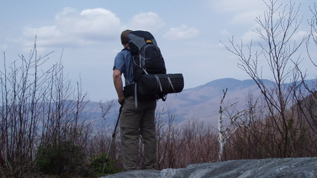
Starting south, the Long Trail takes you through a spruce forest on top of a ridgeline. In fact, it follows the height of land all the way to the Massachusetts border. Even in April the trail was firm in most places and the few mudholes we encountered had stepping stones across them. There was still snow in spots and no sign at all that any hikers (other than a number of moose) had used the trail in the winter. Perhaps winter travelers all use the parallel Catamount Ski Trail which is specifically designed for winter use.

We stopped at the Carleton Mountain lookout for lunch, then wandered down to Route 105, 2.6 miles from the terminus and 4 miles from our car. Continuing another 1.8 miles to Shooting Star was certainly doable, but it would mean retracing all of our route in a hurry the next morning. So we backtracked and spent the night at Journey’s End Camp, a lovely and very comfortable new pine-paneled shelter with bunks for eight. We were the only people there—one of the advantages of hiking in mid-April. So we could spread out as much as we wanted for sleeping and cooking dinner.

At 4:30 the next morning we were awakened by a testosterone-fueled Hairy woodpecker who apparently liked the acoustics produced by drumming his territorial tattoo on the cabin wall. Great alarm clock! After breakfast, a short hike out left us time to drive around to Route 105, and hike to the Shooting Star shelter.
Thus begins a quest to hike the entire Long Trail in sections. We’ll get it done eventually, if not this year, certainly in this decade. The joy is in the journey and the Long Trail a worthy journey indeed.
Life isn’t a spectator sport. Get out and enjoy!
Gear Notes: Long Trail Overnight
Packs:
Tim: Gregory Z-65, my go-to light pack for many years.
David: Go Lite Odyssey
Trekking Poles
Tim: Leki Corklite Aergon Speedlock, Overall the best trekking poles I have ever used. lightweight, sturdy, easy to adjust, great handles.
David: LL. Bean Hikelite 4-season Hiking Poles
Sleeping bags:
Tim: REI Lumen +25 Comfy at 35, not at 25, a little heavy for a 35-degree bag. To see the results of a test of this bag against the LL Bean Katahdin +20, go here.
David: L.L. Bean Katahdin +35
Pads:
Tim: Therm-a-rest Z-rest, replaced by Z-lite, and Insulmat Thermalite, replaced by the Peak Oyl.
David Therm-a-rest RidgeRest and Insulmat Ether
Boots:
Tim: Aku Utah Micro GTX. My go-to midweight boot.
David: L.L. Bean Gore-tex Cresta Hikers
Raingear:
Tim REI Taku jacket and pants, proven bombproof.
David: Red Ledge Free Rein
Stoves: Brunton Raptor and Snow Peak Giga GS 100A
Cookware: GSI Dualist
Headlamp:
Tim: Princeton Tec Fuel 3-AAA
David: Princeton-Tec Aurora (replaced by the Fuel)
Lantern: